| Impact Probability | 100% based on the asteroid’s current trajectory |
|---|---|
| Date of Predicted Impact | 10 July 2038 |
| Impact Location | The asteroid will impact the atmosphere somewhere along a 120 km (70 mile) long and 5 km (3 mile) wide corridor. The asteroid will airburst (disrupt in the atmosphere) somewhere along a corridor approximately 140 km (90 miles) long and 20 km (10 miles) wide that includes Montreal, Canada. |
| Expected Number of People Affected | Populated regions will be affected, with approximately 10,000 to 3 million people potentially affected in Canada and possibly the U.S., depending on the impact location, ground damage extent and severity, and other uncertainties. |
| Expected Damage Level | A destructive blast wave would cause severe, very likely critical, and potentially unsurvivable damage, with serious ground damage most likely extending 35–50 km but potentially up to 100 km. |
| Asteroid Size | Most likely in the range 82–84 meters (270–280 feet) in diameter, but potentially in the range 78–88 meters (260–290 feet). |
| When will there be new information? | The asteroid is currently unobservable. Starting in January 2038—seven months before impact—the asteroid will become observable by optical telescopes on Earth. The asteroid will also be observable by the Hubble Space Telescope and the James Webb Space Telescope starting in January 2038 and March 2038, respectively. On 6 July 2038—four days before impact—the asteroid will be detectable by planetary radar. By 20 June 2038—twenty days before impact—the atmospheric impact location will be known to ±10 km, and on 6 July it will be known to ±3 km. |
Late November 2026: Ground-based optical observations of asteroid 2026 PDC27 resumed and continued until August 2027. The data collected during this observing window improved predictions of the asteroid’s orbit by a factor of 20 and increased the probability of Earth impact on 10 July 2038 to 100%.
January 2028: Ground-based optical observations of asteroid 2026 PDC27 resumed and continued until July 2028 when the asteroid became unobservable. At the end of this observing period the orbital uncertainty for 2038 (i.e., uncertainty in where the asteroid will be in 2038) further decreased by 30%.
June 2031: A space mission to gather additional information about the asteroid flew by the asteroid in June 2031, collecting data as it did so. The optical navigation data collected by the spacecraft provided a positional constraint of approximately 1 km at the time of the flyby. The orbital uncertainties further decreased by a factor of 10 and the location where the asteroid will impact Earth’s atmosphere was predicted to within ±110 km (1-sigma). The data collected from the flyby mission constrained the asteroid’s diameter to 83.0 ± 1.3 m (1-sigma).
July 2034: Ground-based tracking of the asteroid continued until mid-July 2034 when the asteroid became unobservable. At this point, the location where the asteroid will impact Earth’s atmosphere was predicted to within ±20 km (1-sigma). Starting in January 2038—seven months before impact—the asteroid will become observable by optical telescopes on Earth. The asteroid will also be observable by the Hubble Space Telescope and the James Webb Space Telescope starting in January 2038 and March 2038, respectively. On 6 July 2038—four days before impact—the asteroid will be detectable by planetary radar.
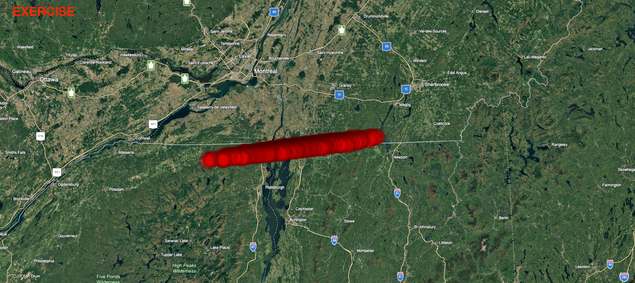
|
| Atmospheric impact location at 100 km above sea level for asteroid 2026 PDC27 |
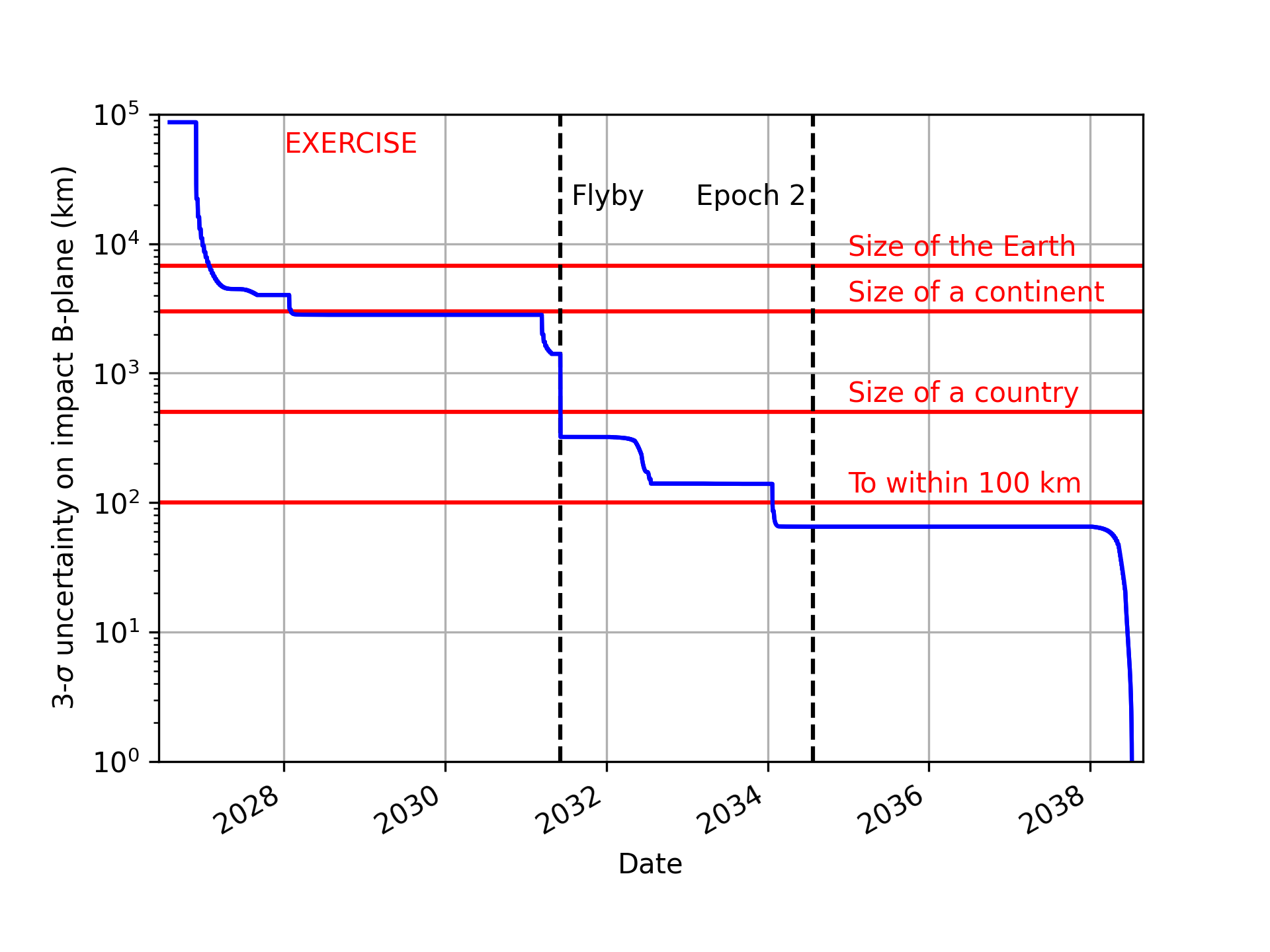
|
| Evolution of the uncertainty on the 2038 B-plane for 2026 PDC27 |
The primary hazard will be a high-energy airburst (disruption in the atmosphere) causing a destructive blast wave. The blast damage will likely extend approximately 35–50 kilometers (20–30 miles) from the airburst location, and possibly as far as 100 kilometers (60 miles). The blast could flatten structures near the damage center, with structure damage and broken windows extending over larger areas. The energy delivered by the asteroid will most likely be in the 20–32 megaton range but potentially in the 13–46 megaton range. Uncertainty in the asteroid’s mass is the primary source of uncertainty in the projected damage.
This damage risk region map shows the extent of regions potentially at risk to local ground damage, which takes into account the uncertainty in the potential airburst location (black border) and potential extent of damage. The shaded colors show the highest potential damage severity that may reach each region (out to the 95th percentile of estimated damage extent). The colored rings show a likely median-size damage footprint at an example location. Damage would only occur around the actual airburst location, not across the entire risk region.
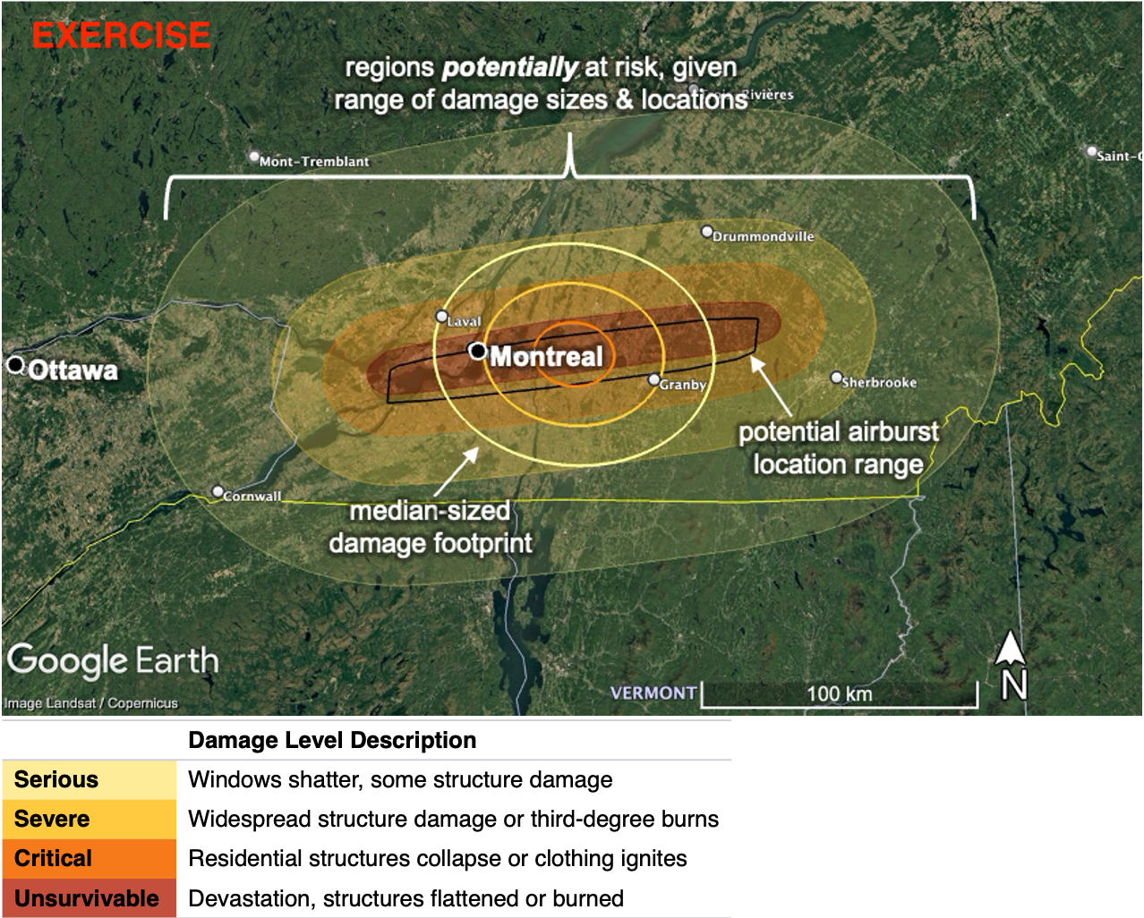
|
| Ground damage risk region map for 2026 PDC27 |
A Google Earth KMZ file of damage risk swath maps and sample damage footprints is available, along with a document describing its contents.